How to Get Around in Colorado Springs
We know that navigating a new city can be stressful, so we’ve created a helpful guide to getting around in Colorado Springs. We have all the information you need on free shuttles, e-bikes, popular routes and traffic strategies. We’re here to help you find your way!
Getting to Colorado Springs
The first step to visiting the Pikes Peak region is getting here. If you are not traveling to Colorado via road trip or bus, that means you’ll need to fly. Colorado has two major airports: Denver International Airport and Colorado Springs Airport.
The Colorado Springs Airport
The Colorado Springs Airport has become a major transportation hub for travelers visiting the Pikes Peak region. It is small, convenient and easy to navigate. It has short TSA lines, quick and easy drop-off and lots of affordable parking. The airport has consistently added new routes for the last several years, which makes it more affordable, too.
Leaving the Colorado Springs Airport
- The airport has rental car companies onsite.
- Many of the area hotels will also offer pick-up and drop-off to DIA.
- Rideshares provide a steady flow of drivers you can pre-schedule or call for rides when you land.
- Mountain Metro Transit provides travel to and from the airport every 40 minutes via bus Route 37. You will need to make more than one transfer to get to your final destination.
Denver International Airport
You will find Denver International Airport (DIA) on the east side of Denver. You can rent a car from one of the many rental providers to drive into Colorado Springs. You can also take a shuttle that will transport you to Colorado Springs with minimal stops.
Denver Airport Shuttle to Colorado Springs
Groome Transportation
Groome Transportation will take you to and from Denver International Airport. The website recommends that you make reservations more than 24 hours before your arrival and departure.
Cost: $44-$59 per adult, one way.
Stops:
- Groome Park & Ride
- Colorado Springs Airport
- Colorado Springs Hotels
- Monument Park & Ride
Traveling in Colorado Springs by Car
Traveling in Colorado Springs by car is most common. The city is huge and seemingly close attractions can actually be further than you think. It’s just faster, easier and more convenient.
Like any other popular destination, however, Colorado Springs has traffic, construction and high-congestion areas. We’ve included a few areas where you might want to plan ahead and give yourself extra time. Or, you can avoid the area during peak traffic hours.
Areas to watch for traffic in Colorado Springs
I-25 Corridor
The peak times for traffic on I-25 are during the early morning commute that runs from 7 a.m. to 9 a.m. The evening commute begins at about 3 p.m. and runs until around 6:30 p.m. You can try to avoid using I-25 during peak hours to save time. However, it is sometimes still the fastest way to get around, even with traffic.
If you are traveling from Denver, the corridor between Castle Rock and Monument can get extremely congested. Use the express lane to bypass the majority of traffic jams. You will not regret spending a few extra dollars to avoid getting stuck.
Manitou Springs
As one of the most popular tourist destinations in the Pikes Peak region, Manitou Springs is always very busy. During major events or hot weekends, you may find yourself in heavy and slow-moving traffic. Take advantage of the town’s free shuttle by parking on the outskirts of town and riding in.
Alternatively, you can also take a Pike Ride or Lime scooter into Manitou using trails and bike lanes. It is a sneaky way to get into town that can beat traffic. It’s also a beautiful ride.
Westbound Highway 24
As you leave Colorado Springs heading west via Highway 24, there are a few hotspots to watch out for. You will encounter traffic near the Manitou Cliff Dwellings. The Pikes Peak Highway/Santa’s Workshop and Woodland Park are also very busy during the day. Woodland Park is especially packed with travelers on weekends and holidays.
Key Roads for Driving in Colorado Springs
When you are driving in Colorado Springs, it is also helpful to become familiar with the main roads. The routes below are common streets that traverse major areas of the city.
East to West / West to East
Highway 24
Highway 24 can bring you from the eastern plains all the way to the mountains. In the city of Colorado Springs, Highway 24 begins on the eastern edge of the city. You will take the bypass route that runs from Powers Boulevard to Fountain Boulevard and eventually merge onto I-25.
The highway continues into the mountains, passing Pikes Peak, through Woodland Park, into Divide and beyond. In Divide, Highway 24 also crosses CO-67, which will take you to Cripple Creek.
Platte Avenue
Platte Avenue begins on the east side of Colorado Springs as part of Highway 24. Where Highway 24 branches off to Powers Boulevard, Platte Avenue continues straight through the city. It crosses Powers Boulevard and Academy Boulevard before ending downtown close to I-25.
Woodmen Road
Woodman Road begins in the town of Falcon, east of Colorado Springs. It continues west, crossing Powers Boulevard, Academy Boulevard and I-25 before it ends.
North to South / South to North
Powers Boulevard
Powers Boulevard is on the east side of Colorado Springs. It begins at Interquest Parkway near northern I-25 and runs south all the way into the city of Fountain. It is part of the Highway 24 bypass route. It is also one of the main routes to the Colorado Springs Airport.
Academy Boulevard
Academy Boulevard begins at I-25 on the north side of Colorado Springs, near the Air Force Academy. It continues south, meeting up with I-25 and Highway 115 before it ends.
Nevada Avenue / Highway 115
Nevada Avenue/Highway 115 is on the west side of Colorado Springs. It runs parallel to I-25 beginning north near the Pro Rodeo Hall of Fame. It then runs south through Downtown Colorado Springs.
As you head out of Colorado Springs, you’ll pass Fort Carson and the Bug Museum. South Highway 115 is also a very scenic drive to Canon City and the Royal Gorge!
Micro-Mobility Options in Colorado Springs: E-Bikes and Scooters
Colorado Springs is a very spread out city. But, the community is hard at work to make it smaller for non-drivers and pedestrians. Two great options for getting around include e-bikes and e-scooters.
PikeRide E-Bikes
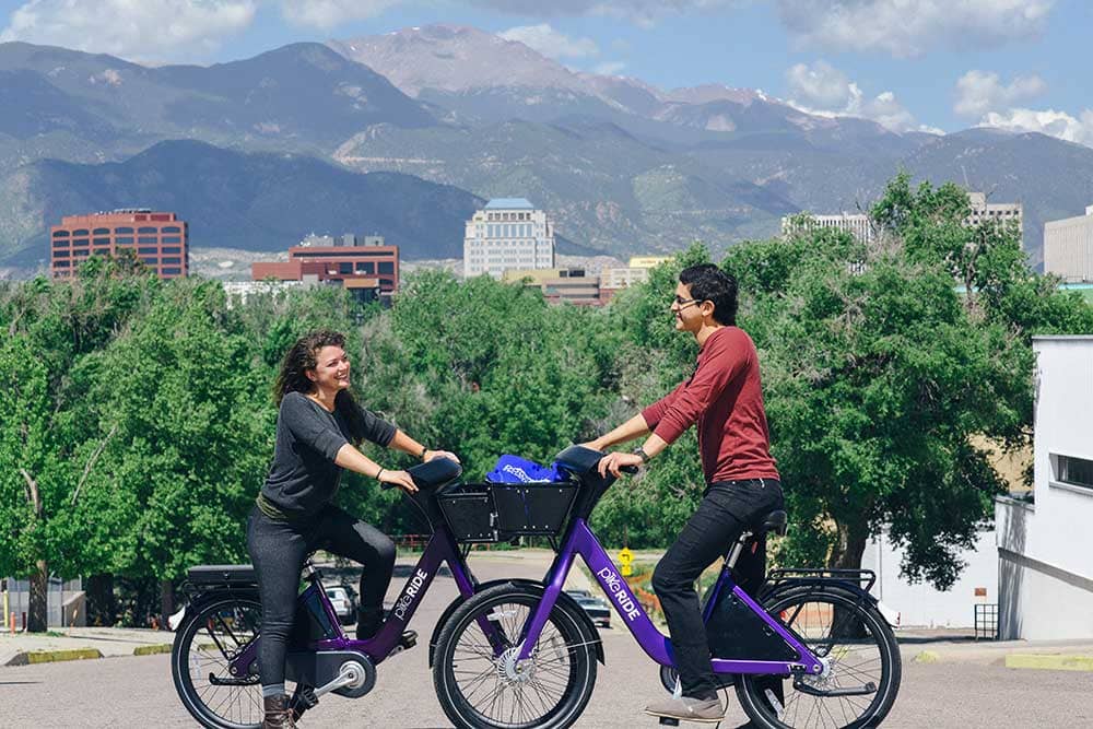
PikeRide is a non-profit bike sharing program in Colorado Springs. PikeRide bicycles use electric-assist motors to help riders move faster and climb hills. You can find PikeRide “stops” all throughout the west side of Colorado Springs.
The bicycle coverage area also includes Old Colorado City and Manitou Springs. Take a look at their coverage map. You will be pleasantly surprised by how many great destinations are in the PikeRide zone.
Tips for Using a PikeRide Bicycle:
- You will need a smartphone to activate your bicycle. Ensure your phone has enough battery life to allow you to lock and unlock your bike throughout your trip.
- Install the PikeRide app before you begin exploring Colorado Springs. Add your payment method to the app before you go.
- PikeRides cost $1 to unlock. The application will then charge you $0.25 per minute until you lock your bike and end your trip.
- You can lock up your PikeRide while you explore. However, the application will continue to charge you by the minute unless you end your trip.
- Riders can save themselves an extra dollar by locking up bikes at one of 60 designated stops. You can use the app to find nearby PikeRide stops.
Lime Scooters
Lime scooters are another option for getting around without a car. They can reach speeds of 15 miles per hour! That means you can move fairly quickly to get where you need to go. They are also really fun to ride for no reason at all!
The coverage area for Lime scooters is larger than PikeRide’s. It spans east to the Citadel Mall and west to Manitou Springs. It also includes the area south to the World Arena and north toward the Pro Rodeo Hall of Fame.
Tips for Riding Lime Scooters:
- Scooters require riders to use a smartphone and download the Lime app.
- The cost is $1 to unlock and $0.42 per minute to ride.
- Lime scooters have no-ride zones. They also have slow-down zones. Your scooter will automatically shut off in no-ride areas. It will automatically slow down in designated slow areas.
- You should try to park your scooter in designated areas. Follow the instructions on the app for leaving your scooter outside of a Lime parking area.
Find great scooter and bike routes in Colorado Springs here.
Popular Shuttles in Colorado Springs
In addition to bikes and scooters, there are several free shuttles in Colorado Springs. These free routes are very useful in more popular areas of the city.
Manitou Springs Free Shuttle Service
Manitou’s free shuttle service runs the full route from April through September. It makes stops at the following destinations ever 10-20 minutes:
- Hiawatha Gardens Parking
- Downtown Manitou Ave
- The Incline
- Pikes Peak Cog Railway
Check the map out here.
The Zeb Free Downtown Shuttle
The Zeb is a free shuttle that runs up and down Tejon Street in Downtown Colorado Springs. Pick-ups are every 7-10 minutes with multiple stops. Stops include:
- Colorado College
- Acacia Park
- Pioneer Museum
- Multiple parking garages
- South Tejon shops and restaurants
- Weidner Field
- U.S. Olympic and Paralympic Museum
Get more details here.
Tips for a More Walkable Trip
If you really enjoy walking when you visit a city, it is possible in Colorado Springs. It is not easy. But it is possible. The key is to stay in the parts of the city that are easier to navigate on foot.
Downtown Colorado Springs
The downtown part of Colorado Springs can be very pedestrian friendly. Hotels like Kinship Landing and the Mining Exchange put you in the heart of the action. You will be walking distance to a variety of restaurants, from fast food chains to fine dining. You’ll also be close to the United States Olympic Museum, several parks, nightlife, Weidner Field and Colorado College.
Old Colorado City
Old Colorado City is another walkable area. Stay on the north side of Highway 24 and close to Colorado Avenue. The area has multiple restaurants, bars, live music and retail shops. There is an amazing farmers market each Saturday in the summer and several other events year-round.
Manitou Springs
Manitou Springs is very compact. Most of the best places for you to visit will be right on Manitou Avenue. You can walk to Miramont Castle and the station for the Cog Railway, as well as the Incline. Pedestrians can also hop on and off the Manitou shuttle to visit area attractions.
Now that You’re Prepared, It’s Time to Get Excited!
We hope these tips will help you feel confident about getting around in Colorado Springs. Our sprawling, hilly terrain does take some getting used to. However, with a little practice, you’ll be cruising around the city just like a local.
